Leveling
Courses > Surveying > Leveling, Bench marks, Turning points > Leveling Introduction
Measuring the difference in elevation between points on the earth's surface is a fundamental part of surveying. These differences in elevation can be determined by various methods of leveling.
Definition
Leveling is the operation of determining the difference in elevation between points on the earth's surface.
Datum
A level reference surface, or datum, is established and an elevation assigned to it. Differences in the determined elevations are substracted from or added to this assigned value and result in the elevations of the points.A level surface is one in which every point is perpendicular to the direction of the plumb line. It differs from a plane surface, which is flat and is perpendicular to a plub line at only one point.
The ocean's level surface is determined by averaging a series of tidal height observations over a metonic cycle (approximately 19 calender years). This average, called mean sea level, is the most common datum for leveling and is usallly assigned an elevation of zero. This datum remains in effect until continuing observations show a significant difference and it becomes worthwhile to change to the new datum. In the United States, the mean sea level datum of 1929 is still in effect.
 Concepts and Formulas
Types of Leveling
Leveling operations are devided into two major categories.
Direct leveling is usually referred to as differential, or spirit, leveling. In this method the difference in elevation betweeen a known elevation and the height of the instrument, and then the difference in elevation from the height of the instrument to an unknown point, are determined by measureing the vertical distance with a precise or semiprecise level and leveling rods. This is the only method that will yeild the accuracies of the third or a higher order.
The second method of leveling, indirect leveling, is further subdivided into two seperate methods, trigonomic and barometric. The trigonometric method applies the principles of the trigonometry to determine differences in elevation; a vertical ansle (above or below a horizontal plane) and a horizontal distance or slope distance (measured or computed) are used to compute the vertical distance between two points. This method is generally used for lower-order leveling where the terrain is prohibitive to direct leveling.
Biometric leveling uses the difference in atmospheric pressure as observed with a barometer or altimeter to determine differneces in elevation. This is the least used and least accurate method of determining differences in elevation. It should only be used in surveys where one of the other methods is unfeasible or would involve large amounts of time or money. Becasue of its limited use, barometric leveling will not be discussed further.
Leveling Equipment
-
Levels
-
Tripods
-
Leveling Rods
-
Rod Targets
-
Hand Levels
-
Tapes
Orders of Accuracy
When writing the specification for a survey, it is very impractical to specify the exact degree of accurcy that is to be attained in each of the measurements. For this reason, specifications are based on the minimum degree of accuracy allowed for the particular survey. The range between the allowed degree of accuracy is known as an order of accuracy, The orders of accuracy for surveys are called first order, second order, third order, and lower order. The measurement for the first order surveys are the most accurate, and the measurement for the other orders are progresively less accurate.
Ordders of accuracy are specified for triangulations, traverse, and leveling. For the measurements made in mapping, orders of accuracy are also specified for the astronomic observations made to establish position and azimuth. As an example of the range between oders of accuracy, let us consider the allowed tavers position closure. Thw first order specifies 1:25,000 or better; second order, 1:10,000, third order, 1:5000.
Level Bench Mark
A bench mark is a relatively permanent object , natural or artificial, bearing a marked point whose elevation is known. A bench mark may be further qualified as permanent, temperary, or supplementary. The purpose of a survey normally governs whether its stations will be permanently or temporarily marked. When it is known that the station may be reused over a period of several years,the satation marker should be of a permanent type. A permanent bench maerk is normally abbreviated BM, and a temperory or suplemental bench mark is abbreviated TBM.
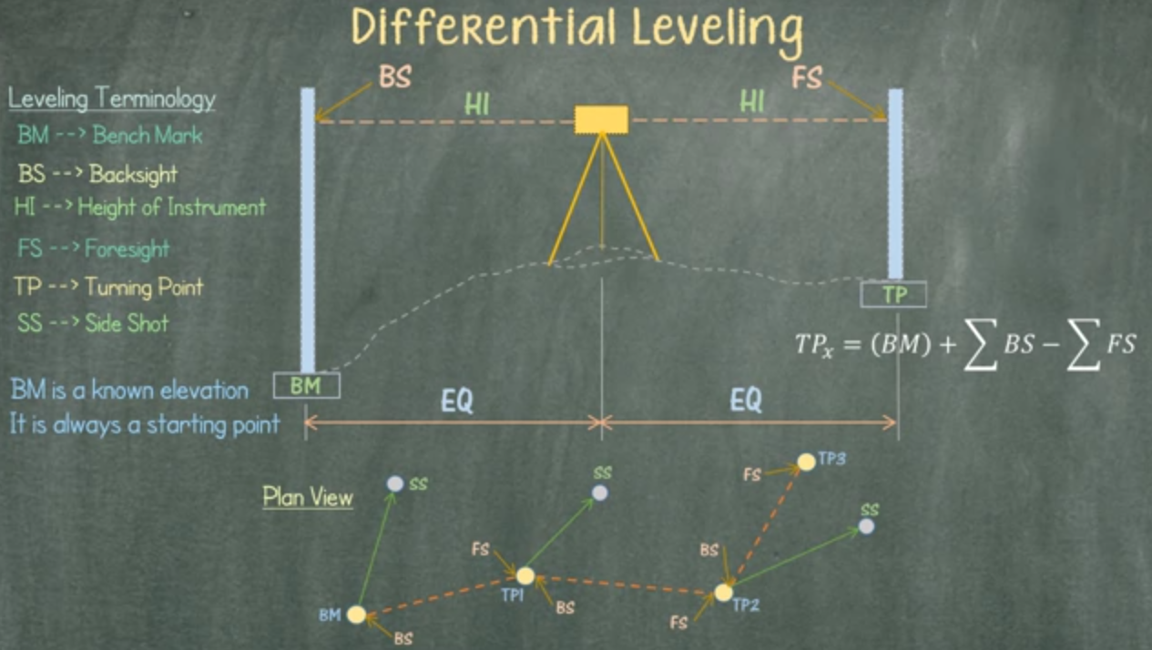
Differential Leveling
In direct leveling, a horizontal line of sight is established using a sensitive level bubble in a level vial. The instrument is leveled and the line of sight is adjusted to be parallel to the level vial axis. When leveled, the line of sight of theinstrument describes a horizontal plane if the instrument is rotated about its vertical axis. See Figure below. This procedure is referred to as differential or spirit leveling.
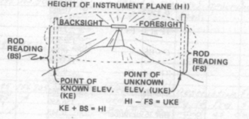
Differential Leveling Terminology
- BM: Bench Mark
- BS: Backsight
- HI: Height of Instrument
- FS: Foresight
- TP: Turning Point
- SS: Side Shot
 Read also
- Theodolite, its types and essential parts
- Full Description of Civil Engineering Branches
- Surveying instruments used in civil and surveying engineering
 Share
Share
Follow our official Facebook page (@civilengineeringbible) and Twitter page (@CivilEngBible) and do not miss the best civil engineering tools and articles!