What are the canals
Articles > What are the canalsCanals
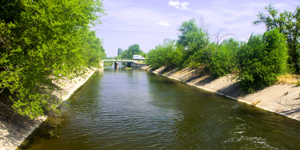
In India particularly northern India, rainfall is almost nil during winter season. Rainfall takes place only during monsoon seasons. However, rivers originating from the Himalyas and flowing through the northern India carry very high discharges. For this reason a canal irrigation system was thought proper for meeting the demand of water for agricultural purposes. Ganges canal was the first canal commissioned in India in the year 1845. British engineers constructed several canals during nineteenth centuries particularly towards the end of the century. Since then network of canals has been extended and today it is the largest system in the world.
Classification of Canals
Canals are classified on the following basis
Based on the Nature of Source of Supply
Permanent or Perennial Canal: It is one which is fed by a permanent source or ice. It is a regular graded channel and has permanent masonary works of regulation and distribution of supplies {i.e. head works, regulators and distributaries).
Inundation Canal: It is one which gets supply only during floods. It is not provided with any headwork for diversion of river water to the canal. However, a head regulator is provided.
Based on Financial Output
Productive Canal: It is one which earns revenue to the nation.
Protective Canal: It is one which is constructed with an idea of saving a particular
region from famine.
Based on the Function of the Canal
Irrigation Canal: It is one which carries water to the fields.
Carrier Canal: It irrigates land and in addition carries water for other canals. (Upper Chenab canal in West Punjab, Pakistan is an example of such a canal.)
Feeder Canal: It is used for feeding two or more canals
Navigation Canal: It is constructed with an idea to use it for navigation purposes.
Power Canal: It is a canal which is used for feeding water to the turbine for generating power.
Based on Discharge and its Relative Importance
Main Canal: It takes off directly from river or upstream side of head works. It acts as carrier canal and feeds water to branch canal and major distributaries. It is not used for irrigation except in exceptional cases. It carries heavy discharge.
Branch Canal: It takes off from the main canal. It is not used for direct irrigation. These canals act as feeder canals for major and minor distributaries. A branch canal usually carries a discharge of more than 5 m3/s but less than 20 m3/s.
Major Distributary: It is known as Rajbaha. It takes off from a branch canal but sometimes may take off from the main canal. Distributaries supply water to the fields through outlets. Thus they are used for irrigation purposes. Discharge in such canal varies from 0.25 m3/s to 5 m3/s. These channels are aligned along watershed or as side slope channels.
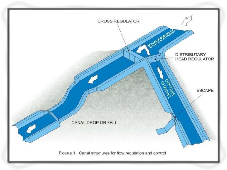
Minor Distributary: It takes off from branch canal or from major distributary. Such canals are also called as minors. They carry a discharge less than 0.25 m3/s. They supply water to the water courses through outlets. These are constructed only when the distance between the distributary outlet and farmer's field is more than 3 km.
Minor Distributary: It takes off from branch canal or from major distributary. Such canals are also called as minors. They carry a discharge less than 0.25 m3/s. Ihey supply water to the water courses through outlets. These are constructed on y w len the distance between the distributary outlet and farmer's field is more than 3 km.
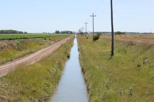
Water Course: Also known as field canal, is used for feeding water to the irrigation fields from government owned outlets. It may take off from a major distributary or minor or even branch canal depending on the size and extent of irrigation scheme. These channels are constructed by cultivators.
Based on Canal Alignment
According to the alignment, a canal may be classified as-
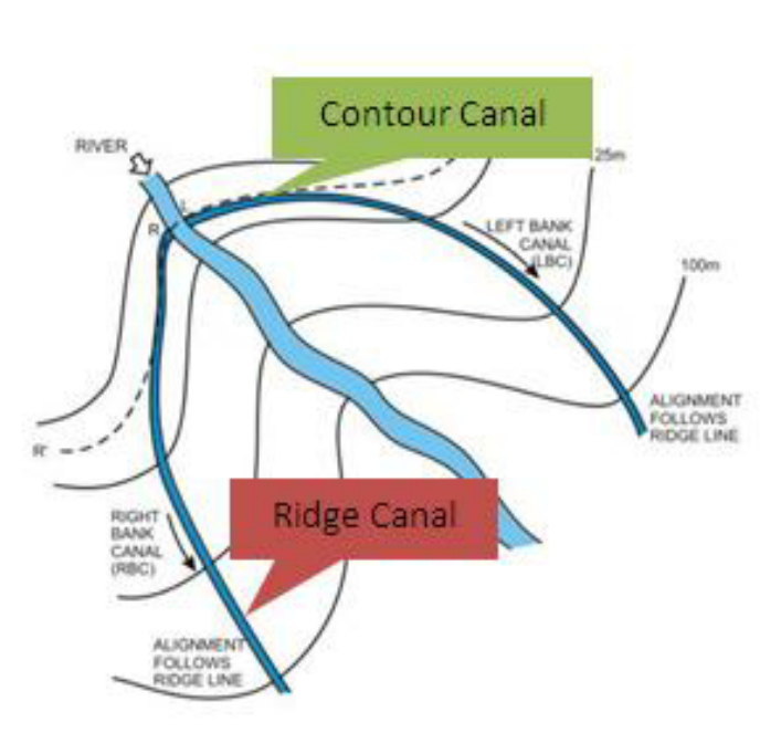
Watershed canal or ridge Canal: It is a canal which is aligned along a watershed and runs for most of its length on a watershed. It can irrigate fields on both sides.
Contour Canal: It is a canal which is aligned parallel to the contours and irrigates area only on one side of it. The other side being at higher elevation.
Side Slope Canal: It is a canal which is aligned roughly at right angles to the contours of the country. It is constructed neither on the watershed nor in the valley.
Based on Material of Construction
Lined Canal: Canals with an intention to reduce seepage are lined with different materials. These materials include, concrete, shotcrete or plaster, brick or concrete tile, asphaltic concrete, boulder, compacted earth and soil cement.
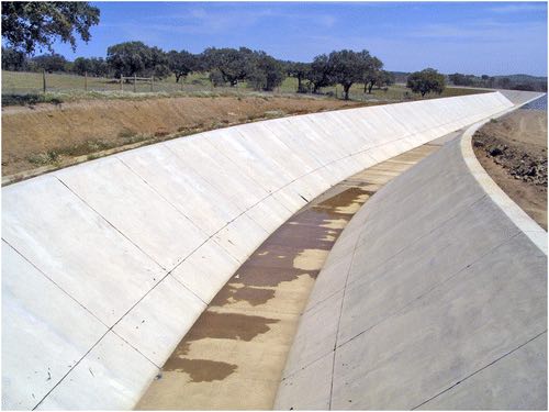
Cement concrete lining: It is considered as high quality type of lining. Its initial cost is large. Steeper slopes exert extra earth pressure rendering the lining as uneconomical. The lining is cured for 3-5 days. The surface is kept continuously wet during this period.
Shotcrete lining: In this type of lining cement mortar (a mixture of cement: sand in the ratio of 1:4) is applied under pressure through a nozzle on the surface of canal. Size of sand is limited to 5 mm and thickness of lining is 35 mm.
Brick or concrete tile lining: This type of lining is very popular in our country. A single or double layer of tiles is laid over a layer of brick masonary or tiles laid in mortar. The top layer of tiles is laid in 1: 3 cement mortar over 12 mm to 15 mm thick layer of plaster in 1 : 3 cement plaster. The second layer is over it in 1:3 cement mortar. The size of brick especially made is kept as 300 x 150 x 50 mm.
Asphaltic concrete lining: It is a cheap lining and consists of mixture of asphalt and graded stone aggregate placed at a temperature of 200°C. It is covered with a 300 mm layer of earth material for protection. It is not in common use.
Boulder lining: It is also called dry stone lining or stone pitching. The thickness and size of lining depend on the canal capacity. For example if the capacity is less than 50 m3/s, recommended thickness is 150 mm, average diameter along longest axis = 150 mm and minimum diameter = 75 mm. Whereas for Q = 100 m3/s and above, recommended thickness is 300 mm, average diameter along longest axis = 300 mm and minimum diameter = 150 mm. Precast concrete slabs 900 x 300 x 60 mm are also used for lining of canal. Joints are sealed with asphalt to prevent seepage.
Compacted earth lining: Suitable soil available in the area is compacted at optimum moisture content and is used for lining. Its thickness is kept as 300-900 mm.
Soil-cement lining: Mixture of soil having high percentage of fines and 2 to 8% of Portland cement is compacted and used for lining. There are other materials also which are used for lining. These materials are clay puddle, sodium carbonate, stone block, pre-fabricated light weight membrane, bentonite and clay membrane and road oil.
Unlined Canals: Such canals are aligned and excavated either in alluvial soils or non alluvial soils. An alluvial soil is one which is formed by the continuous silt deposition. The area of alluvial soil is comparatively even and has flat slope. Rocky plain area formed due to disintegration of mountaineous region is called as non-alluvial area. Canals through such an area are called as non-alluvial canals. Larger portion of Maharashtra state is non-alluvial.
 Read also:
- How to locate the canal fall/ Factors determining the location of canal fall
- What is engineering and why do they need probability and statistics?
- Rapid Hardening Cement (RHC) use cases; Pros and Cons
- Full Description of Civil Engineering Branches
- Four types of Civil Engineering Drawings
 Share:
Follow our official Facebook page (@civilengineeringbible) and Twitter page (@CivilEngBible) and do not miss the best civil engineering tools and articles!